B6 Mathematics · Term 3, Week 4
Geometric Reasoning
Lesson notes
Learning Objectives
Indicator: B6.3.3.4.1 - Tell the position and motion of objects in space using the cardinal points north-east, north-west, south-east and south-west
By the end of the lesson, learners can:
- Identify and name the four intermediate cardinal points: north-east, north-west, south-east and south-west.
- Describe the position of an object relative to another object using the intermediate cardinal points.
- Describe the motion of an object from one point to another using the intermediate cardinal points.
- Give step-by-step directions (including distance in squares) from one location to another on a grid using cardinal points.
- Use a compass rose correctly to determine and justify positions of objects in the classroom and on a map.
Sign in with your phone number to read the full note and download the GES plan - free.
Sign in with phone numberCurriculum details
- Strand
- Geometry and Measurement (Strand 3)
- Sub-strand
- Geometric Reasoning (3.3)
- Content standard
- B6.3.3.4 - Describe the position of objects in space using the cardinal points
- Indicator
- B6.3.3.4.1 - Tell the position and motion of objects in space using the cardinal points north- east, north-west, south-east and south-west
- Suggested placement
-
Term 3, Week 4
(Week 28 of the year)
Our suggestion, laid out in curriculum order across three terms of twelve weeks. NaCCA does not fix the week, so follow your school's scheme of learning.
- Source document note
-
The official curriculum document has a fault in this entry, so the curriculum text above is transcribed exactly as printed:
- exemplars - p.146
- Curriculum reference
-
Mathematics Curriculum for Primary Schools (Basic 4-6), 2019, p. 146
Transcribed from the official NaCCA publication. Check this page against the source.
Exemplars (from the NaCCA curriculum)
E.g. 1. Pupils describe the position and motion of objects from one point to another using the 4 main cardinal points and the half-betweens: e.g. The point P is north of the point P X but north-west of point C. Y is south of T but south-west of C.

E.g. 2. Pupils describe the position of places in a grid from a given location. E.g. the church is north-east from Kofi's house; the hospital is north-west from Kofi's house.
E.g. 3. Ask learners to give directions from Kofi's house the various locations. E.g. Move 2 squares to the east and 2 squares to the north to get to the church.
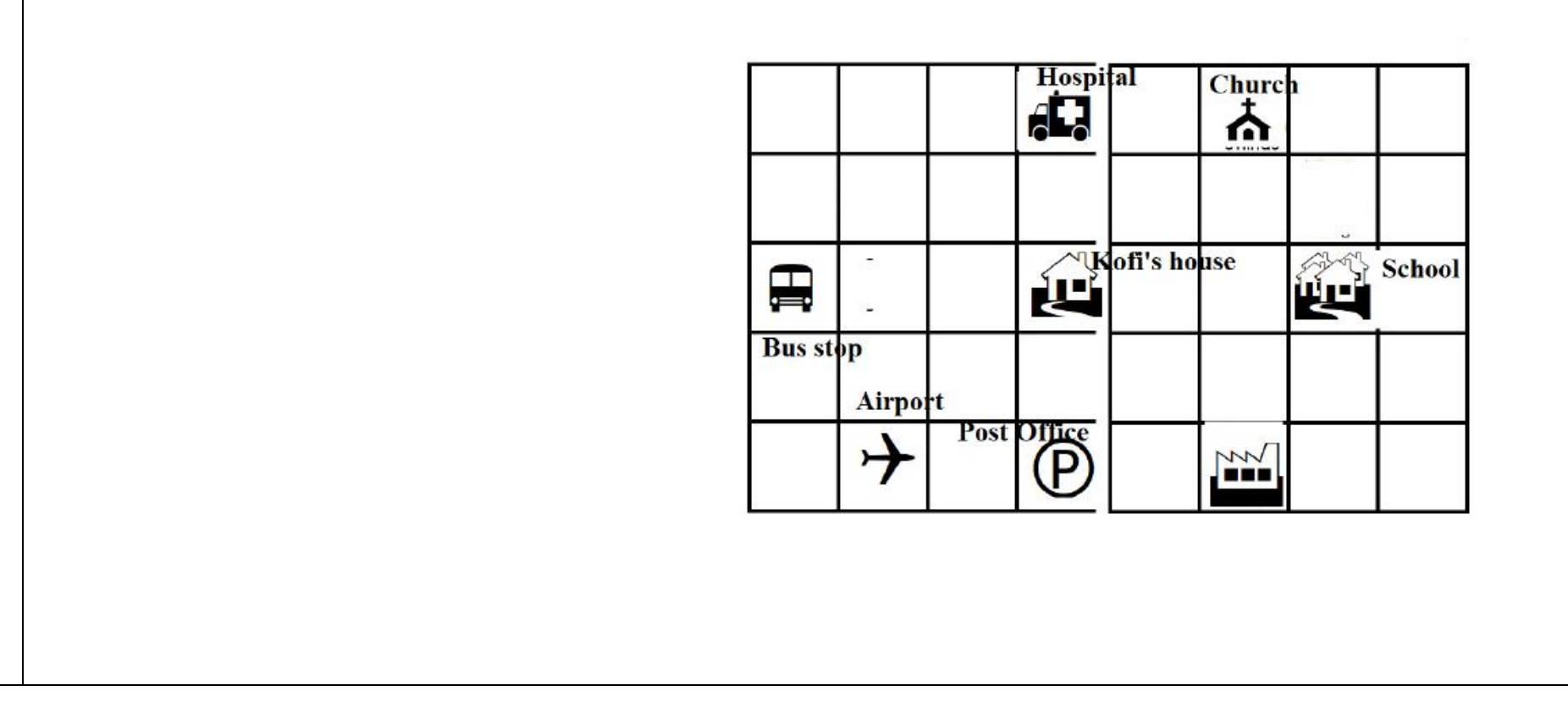
**The document gives two different indicators the same code.** This row is the one printed on p.146, under content standard B6.3.3.5 "Describe the position of objects in space using the cardinal points". Printed p.147 prints a completely different indicator - "Perform and identify images of a single transformation (i.e. reflection) on 2D shapes in a plane" - also coded B6.3.3.5.1, under a content standard also coded B6.3.3.5 but reading "Perform a single transformation (i.e. reflection translation) on a 2D shape". Both are transcribed; the CSV therefore contains B6.3.3.5.1 twice and a human must renumber one of them before import.